Rhonda
HCI Forum Board Member
Posts: 279
|
Post by Rhonda on Feb 20, 2010 20:41:56 GMT -5
Here is what I have discovered in my family history. I think someone has the Elizabeth ladies mixed up.
Capt. Wm. Jones Lucas married Mary Elizabeth Crump. Capt. Lucas became president of 1st National Bank. His wife succeeded him as president after he died. (They are my great-great-grandparents.)
They had 5 children.
1. Mary Crump Lucas...married William Harvey Lincoln (They were my great-grandparents)
2. Francis Crump Lucas...married Jessie Lynn Lincoln (Jessie was William Harvey's sister)
3. Elizabeth Lucas...married Thomas C. Gould in about 1902, and then married Francis E. Stevens, sometime before May of 1906.
Elizabeth had a daughter, Elizabeth Gould, who died at age 3. The obituary states that little Elizabeth's mother was Mrs. (Elizabeth) Francis E. Stevens, and that the child died at the home of her grandmother, Mrs. Elizabeth Lucas. Elizabeth Stevens died in Los Angeles on October 6, 1969. Her only surviving child at that time was Carol S. Connell.
4. Emelia C. Lucas...died at 10 months old
5. George Holmes Lucas...married Naomi Favorite. She was killed in a car wreck near Lafayette, IN. He then married Geneveive C. ?
|
|
|
|
Post by leejunkins on Feb 23, 2010 14:05:46 GMT -5
Here is what I have discovered in my family history. I think someone has the Elizabeth ladies mixed up. Capt. Wm. Jones Lucas married Mary Elizabeth Crump. Capt. Lucas became president of 1st National Bank. His wife succeeded him as president after he died. (They are my great-great-grandparents.) They had 5 children. 1. Mary Crump Lucas...married William Harvey Lincoln (They were my great-grandparents) 2. Francis Crump Lucas...married Jessie Lynn Lincoln (Jessie was William Harvey's sister) 3. Elizabeth Lucas...married Thomas C. Gould in about 1902, and then married Francis E. Stevens, sometime before May of 1906.
Elizabeth had a daughter, Elizabeth Gould, who died at age 3. The obituary states that little Elizabeth's mother was Mrs. (Elizabeth) Francis E. Stevens, and that the child died at the home of her grandmother, Mrs. Elizabeth Lucas. Elizabeth Stevens died in Los Angeles on October 6, 1969. Her only surviving child at that time was Carol S. Connell.4. Emelia C. Lucas...died at 10 months old 5. George Holmes Lucas...married Naomi Favorite. She was killed in a car wreck near Lafayette, IN. He then married Geneveive C. ? Ronda, Do you know anything about the Stevens family My grand mother was Henieretta Stevens daughter of George Stevens. He was married to Nancy and I can not find her maiden name? |
|
|
|
Post by David Sechrest on Apr 29, 2010 12:45:00 GMT -5
Interesting to note: Jean Prather wrote an article for the Evening Republican, dated November 9, 1973 and states that John Crump once lived in the large house at 25th and Marr Road. At the time he lived there, the area was known as Crump's Corner.
I never knew that. More importantly, I would really like to know exactly when he lived there. From all I've read, when he moved back to Columbus with his wife, they lived at and farmed the old Crump Homestead (Francis J. Crump I, Mead Village). Then, they had the house on 7th and Lafayette built and moved into that. So, once again, I'm confused. Maybe he farmed the Crump Homestead (Mead Village), and lived in the house at 25th and Marr Rd?
Could the "Crump Homestead" the paper referred to actually be the area at 25th and Marr Road? Jeff, if you're reading this, can you shed any light on this?
Also, in reading through books such as William Marsh's I Discover Columbus and the 1879 Atlas, mention is made of places like the McEwan (sp?) Block. It was located where the Belvedere Hotel was. Apparently, McEwan had his bank there before John Crump purchased the old Bissell Hotel and remodeled it, becoming the Belvedere.
I never knew that either.
|
|
|
|
Post by David Sechrest on Apr 29, 2010 23:10:26 GMT -5
I wrote: Interesting to note: Jean Prather wrote an article for the Evening Republican, dated November 9, 1973 and states that John Crump once lived in the large house at 25th and Marr Road. At the time he lived there, the area was known as Crump's Corner.
I never knew that.Here is the land map from the 1879 Illustrated Historical Atlas, Bartholomew County  Note a few things here (black rectangles denote houses, among other things): John S. Crump's property, Francis J. Crump I's property, and the James Marr property. Granted, this map is 1879, but according to reported accounts, John Crump farmed the "Crump Homestead" until 1887, then moved into the house at 7th and Mechanics (Lafayette). City directories denote him as a farmer (occupation) and living at the location denoted on the map, before he moved into town. Interesting to note where the house is on John Crump's land, as well as the family graveyard (marked by a cross, two years before the death of his father and where he remains buried to this day. I do not know if Francis' wife passed before him or not). Hartsville Turnpike, if you can make it out, is not 25th Street, but an continuation of 10th Street, and runs directly south of James Marr's property. 25th Street does not appear on any Sanborn Insurance Map until 1927 (possibly before. It doesn't show up on the 1912 map). The Hope Turnpike seems to be more in line with 25th Street here. John Crump died in 1920. At the time of his death, he lived on Lafayette. While I question the remarks in the newspaper, I won't deny them at this point. Lord knows I've done that enough and been flat out wrong about things. Could also be that mystery Crump home photo I've posted here was located at that residence location on J. S. Crump's property. It's a possibility at this point in time... Also, I sure can envision that area just south of J. S. Crump's residence being called Crump's Corner, what with his father's property adjoining in the turn. |
|
jdhinkle
HCI Forum Board Member
LITTLE HINK
Posts: 330
|
Post by jdhinkle on Apr 30, 2010 13:15:58 GMT -5
DAVID IM HAVING A LITTLE TROUBLE FIGURING OUT THIS MAP IT APPEARS TO ME THE DARKENED PART IS MORE LIKE THE DOWNTOWN AREA OF COLUMBUS BASED ON FLAT ROCK AND HAW CREEK MY MEMORY OF 25TH AND MARR ROAD WAS REFERRED TO AS THE CRUMP ESTATE WHICH IS SUPERFULOUS I THINK THE APTS ACROSS 25TH FROM THE ESTATE WAS CALLED SIMS APTS THE NAMES ON THE DIFFERENT PEICES OF PROPERTY ARE INTERSTENG SUCH AS BEAM, MARR AND GREAVES I HAVE BEEN TRYING TO FIND OUT HOW LINCOLN PARK CAME ABOUT AS ARE SOME OF THE OTHER MEMBERS THIS MAP MAY SHED SOME HELP AFTER FURTHER STUDY IT APPEARS TO ME THE HOPE TURNPIKE IS 25TH AND YOU CAN SEE THE JOG WHERE BEAM ROAD ALONG THE BEAM PROPERTY AND THEN MARR ROAD TP THE RIGHT THATS WHERE I THINK THE CRUMP ESTATE WAS THAT I REFER TO THE DOTTED ROAD BETWEEN SIMS AND BEAM PROPERTY INTERSECTS WITH HOPE TURNPIKE IS 25TH AND BEAM RD I wrote: Interesting to note: Jean Prather wrote an article for the Evening Republican, dated November 9, 1973 and states that John Crump once lived in the large house at 25th and Marr Road. At the time he lived there, the area was known as Crump's Corner.
I never knew that.Here is the land map from the 1879 Illustrated Historical Atlas, Bartholomew County Note a few things here (black rectangles denote houses, among other things): John S. Crump's property, Francis J. Crump I's property, and the James Marr property. Granted, this map is 1879, but according to reported accounts, John Crump farmed the "Crump Homestead" until 1887, then moved into the house at 7th and Mechanics (Lafayette). City directories denote him as a farmer (occupation) and living at the location denoted on the map, before he moved into town. Interesting to note where the house is on John Crump's land, as well as the family graveyard (marked by a cross, two years before the death of his father and where he remains buried to this day. I do not know if Francis' wife passed before him or not). Hartsville Turnpike, if you can make it out, is not 25th Street, but an continuation of 10th Street, and runs directly south of James Marr's property. 25th Street does not appear on any Sanborn Insurance Map until 1927 (possibly before. It doesn't show up on the 1912 map). The Hope Turnpike seems to be more in line with 25th Street here. John Crump died in 1920. At the time of his death, he lived on Lafayette. While I question the remarks in the newspaper, I won't deny them at this point. Lord knows I've done that enough and been flat out wrong about things. Could also be that mystery Crump home photo I've posted here was located at that residence location on J. S. Crump's property. It's a possibility at this point in time... Also, I sure can envision that area just south of J. S. Crump's residence being called Crump's Corner, what with his father's property adjoining in the turn. |
|
|
|
Post by David Sechrest on Apr 30, 2010 13:21:05 GMT -5
Jack, the darkened part is the city boundaries of Columbus in 1879. I know it's a little confusing, especially looking at such a small version on a computer screen.
I will see if I can post a larger version on photobucket that you can save to your computer.
|
|
|
|
Post by David Sechrest on Apr 30, 2010 13:32:35 GMT -5
Jack (and anyone else), Click on this thumbnail, then click again when it loads to get the full size, then save it to your computer by right clicking and "Save Image As":  This scan includes much more of the page than what I posted above. Bob, you may also want to take a look at this, as it denotes land owned by an L. T. Records. I would not advise trying to print this out, as the physical size is only 6" x 8", however, you can get a very good look at it on your computer monitor. OOPS! You'll notice, down at the bottom of this scan, that the page slipped while I was trying to hold it during scanning! UPDATE: I uploaded this a second time and enlarged this scan a little more. It's scanned at 400 dpi, so if you use Adobe to open it up, go into IMAGE-->IMAGE SIZE--->then decrease the dpi and INCREASE the pixel width of the image (and you can make this VERY large). |
|
RER
HCI Forum Board Member
"Democracy & Freedom"
Posts: 2,462 
|
Post by RER on Apr 30, 2010 14:27:08 GMT -5
David Sechrest Said: Bob, you may also want to take a look at this, as it denotes land owned by an L. T. Records.
David my great, great, great grandfather arrived and lived in Bartholomew County during 1821. His name was Spencer Records and he had many children. Born in Delaware during 1762 and died in Indiana during 1850. Many books have been written about his adventures. He was a frontiersman and he and his father fought in the American Revolutionary War. He was a very young man at war.
Anyway, his offspring's throughout time produced many other grandfathers to lead up to my family, and of course they had many children just like most families. The next great, great , grandfather's life was 1801-1889; then my great, grandfather 1840-1926 and the last grandfather was born in 1865 and died in 1940 before I was born.
My Point: There were many family members that lived on their farms in Atterbury, Bartholomew County and Johnson County. Most of these folks are buried in Edinburg, Mount Auburn (near Edinburg) and some in Shelby County. You mentioned L. T. Records and he was one of the children of all these grandfathers, but not sure which one. The Mount Auburn Church graveyard has the oldest family members buried. That is where Spencer Records, wife and many sons and daughters lay to rest. So, the land mentioned on the map is interesting, but Atterbury had the most family farms before the Government bought them off.
David A Special Note: At the top of the map is S. R. Quick (Sarah Records Quick). This is Spencer Records daughter that married Tunis Quick the State Legislator during those days.
Thanks for the heads up on that land plot, it is interesting. Land plots for the Atterbury land of the past show my grandfathers land and all his brothers.
|
|
|
|
Post by David Sechrest on Apr 30, 2010 14:31:46 GMT -5
Ok, when Francis J. Crump I passed on, the paper stated he was buried at the Crump Homestead (i.e., the land on the map showing where John S. Crump lived).
I've always believed THAT was the Crump Homestead.
If so, then who (Crump) did live at 25th and Marr Rd? And when did they live there?
The paper also reported that when John Crump moved back to Columbus from Kansas, that F. J. Crump I moved into town, closer to the bank. Funny that "residence" is noted on the J. S. Crump property, but NOT on the F. J. Crump property.
Timeline as I thought I understood it: F. J. Crump originally built the house and lives where John Crump's residence is shown on the map. John moves back from Kansas and takes up residence there (his father giving him that land and house?), then F. J. moves into Columbus closer to the bank due to health concerns. John works the farm through the time he moves into the city on Lafayette, and after.
More thinking aloud here...
|
|
jdhinkle
HCI Forum Board Member
LITTLE HINK
Posts: 330
|
Post by jdhinkle on Apr 30, 2010 16:09:11 GMT -5
david and all i got a map from my map book that i think will give a better feeling of where everythink is in my case i was looking for lincoln park on you map  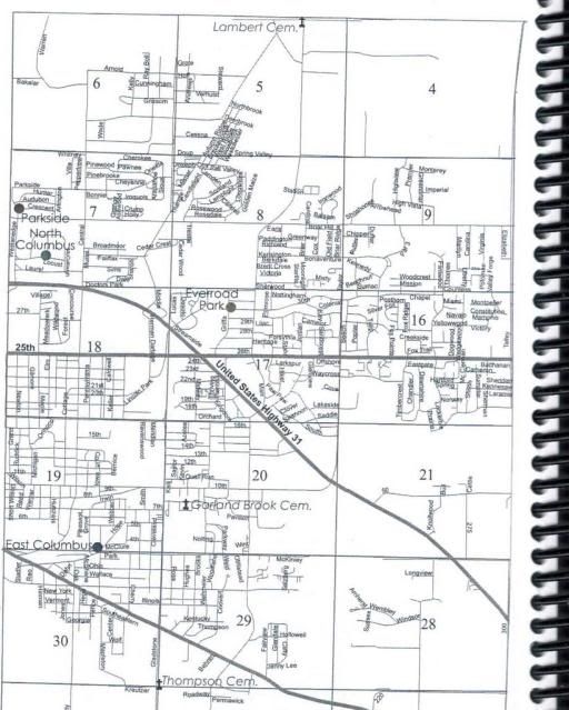 it appears that the graves property on you map might encompass the lincoln park and city colf club and some of garland brook cemetery i have to get the map into my photo thing ill put it here with more explanation I SEPERATED IT INTO TWO SHOT IF YOU COMPARE THIS MAP TO THE ONE DAVID POSTED WHERE THE 17 IN ONE VS THE OTHER GIVES YOU THE AREA YOUR LOOKING AT THIS MAP IS THE EARLY BEAKDOWN OF THE LAND ISSUES DAVID IM HAVING A LITTLE TROUBLE FIGURING OUT THIS MAP IT APPEARS TO ME THE DARKENED PART IS MORE LIKE THE DOWNTOWN AREA OF COLUMBUS BASED ON FLAT ROCK AND HAW CREEK MY MEMORY OF 25TH AND MARR ROAD WAS REFERRED TO AS THE CRUMP ESTATE WHICH IS SUPERFULOUS I THINK THE APTS ACROSS 25TH FROM THE ESTATE WAS CALLED SIMS APTS THE NAMES ON THE DIFFERENT PEICES OF PROPERTY ARE INTERSTENG SUCH AS BEAM, MARR AND GREAVES I HAVE BEEN TRYING TO FIND OUT HOW LINCOLN PARK CAME ABOUT AS ARE SOME OF THE OTHER MEMBERS THIS MAP MAY SHED SOME HELP AFTER FURTHER STUDY IT APPEARS TO ME THE HOPE TURNPIKE IS 25TH AND YOU CAN SEE THE JOG WHERE BEAM ROAD ALONG THE BEAM PROPERTY AND THEN MARR ROAD TP THE RIGHT THATS WHERE I THINK THE CRUMP ESTATE WAS THAT I REFER TO THE DOTTED ROAD BETWEEN SIMS AND BEAM PROPERTY INTERSECTS WITH HOPE TURNPIKE IS 25TH AND BEAM RD I wrote: Interesting to note: Jean Prather wrote an article for the Evening Republican, dated November 9, 1973 and states that John Crump once lived in the large house at 25th and Marr Road. At the time he lived there, the area was known as Crump's Corner.
I never knew that.Here is the land map from the 1879 Illustrated Historical Atlas, Bartholomew County Note a few things here (black rectangles denote houses, among other things): John S. Crump's property, Francis J. Crump I's property, and the James Marr property. Granted, this map is 1879, but according to reported accounts, John Crump farmed the "Crump Homestead" until 1887, then moved into the house at 7th and Mechanics (Lafayette). City directories denote him as a farmer (occupation) and living at the location denoted on the map, before he moved into town. Interesting to note where the house is on John Crump's land, as well as the family graveyard (marked by a cross, two years before the death of his father and where he remains buried to this day. I do not know if Francis' wife passed before him or not). Hartsville Turnpike, if you can make it out, is not 25th Street, but an continuation of 10th Street, and runs directly south of James Marr's property. 25th Street does not appear on any Sanborn Insurance Map until 1927 (possibly before. It doesn't show up on the 1912 map). The Hope Turnpike seems to be more in line with 25th Street here. John Crump died in 1920. At the time of his death, he lived on Lafayette. While I question the remarks in the newspaper, I won't deny them at this point. Lord knows I've done that enough and been flat out wrong about things. Could also be that mystery Crump home photo I've posted here was located at that residence location on J. S. Crump's property. It's a possibility at this point in time... Also, I sure can envision that area just south of J. S. Crump's residence being called Crump's Corner, what with his father's property adjoining in the turn. |
|
RER
HCI Forum Board Member
"Democracy & Freedom"
Posts: 2,462
|
Post by RER on Apr 30, 2010 16:58:55 GMT -5
David: Reference your 1879 Plot Map (at very top)S. R. Quick My Great, Great Great Grandfather Spencer Records' daughter was named Sarah. The land at the top was hers under the name Sarah Records Quick. She married Tunis Quick the State Legislator and Educator. Below is a partial of the land map again. I have made a red oval at the top around her name S. R. Quick. The story goes that when Spencer and Elizabeth Records were in older age they both moved in with Tunis and Sarah (Records) Quick. The land probably was Spencer's at a given time and given to Sarah Records Quick under her name. Her father Spencer died in 1850 which would have been 29 years earlier, when this plot map was made in 1879. Her mother died in 1874 four years before the map. Spencer lived 98 years and his wife 99 years. Talk about health and hard working people.  Source: Source: From family documents and conversation with my brother.
|
|
|
|
Post by David Sechrest on Apr 30, 2010 18:02:08 GMT -5
Thanks Gregg! Great to hear from you and hope you are doing great. Coming up for the reunion? It does appear to be from that time, doesn't it?
Thanks for the info, Bob! BTW, do you have the 1879 Atlas? It's a wonderful reference guide, if you don't have it in your collection. It offers plat maps for every township in the county.
Jack, is it possible for you to scan that page (i.e., making it larger) and put it on imageshack, similar to what I did with the 1879 plot map? If you need help, I'll try to walk you through it.
|
|
|
|
Post by David Sechrest on Apr 30, 2010 18:05:34 GMT -5
I'm trying to understand all this and maybe I'm thinking of a different place, but I thought the house that sits on the northeast corner of 25th and Marr Rd. once belonged to Ray Marr.
I've provided a roots/ancestry bio of the Marr family (James Marr) in the Columbus Indiana Residents Of Distinction Thread.
Anyway, the article in the Marr Folder states the house was built in 1872 (maybe a different home?). Yet, on the plat map from 1879, it definitely shows this property owned by F. J. Crump. I guess I've always assumed that all that property was owned by the Marr family, but that doesn't seem to be the case for the time period in question.
|
|
|
|
Post by David Sechrest on May 1, 2010 0:07:40 GMT -5
Jack said: it appears that the graves property on your map might encompass the lincoln park and city colf club and some of garland brook cemeteryJack, did you see this from my earlier post? (see reply #26) scale: 2 inches = one mile Yes. The railroad tracks that run east-west above the word COLUMBUS in the darkened area are the tracks just south of me. Just south of 14th Street by the Coke Plant. the JM&I tracks run across the city and then cut up northeast and cut across W M Greaves land. Lincoln Park would be to the east of the tracks. Look at East Columbus and follow that north south road up to Hartsville Turnpike. That north-south road would be Gladstone today. I'm pretty sure it must be Gladstone because, if you follow it south, it eventually crosses Clifty Creek. Hartsville Turnpike is 10th Street. The "striped" road are toll roads. I believe the — — — roads designate a dirt road or more likely, nothing but a path or sorts. Even the river, shows those dotted lines. Also, that road that runs north-south on the east side of Columbus, just slightly to the right and above the letter "S" in Columbus is Union St. It continues on up through F. J. Crump's property and after a couple of jogs, goes east. That would be 25th Street. Follow that up to where there's a cut off to the north (above the numeral 17), and that north-south road would be Marr rd. Don't know if you can read it or not, but that circle there designates a blacksmith shop. I find these old maps fascinating to look at. There's the Lard Factory south of Columbus, right on the river. The County Poor Farm, the Toll Gates, the almost haphazard way the roads are laid out. That spur that wraps around underneath the word Columbus would eventually and partially be done away with, but remember how when you crossed the tracks just above 22nd on Central, there were double tracks laid? Those were added onto at some point. Fun stuff. |
|
Rhonda
HCI Forum Board Member
Posts: 279
|
Post by Rhonda on May 1, 2010 18:10:18 GMT -5
Answering David's question:
"Interesting to note where the house is on John Crump's land, as well as the family graveyard (marked by a cross, two years before the death of his father and where he remains buried to this day. I do not know if Francis' wife passed before him or not)."
According to my family history, Francis' wife, Emilia Smith Crump, died February 7th, 1846, which was 35 years prior to when Francis died. They had been married not quite 20 years, and had 7 children by then. I'm trying to locate my tombstone photos.........
|
|
|
|
Post by David Sechrest on May 1, 2010 22:46:44 GMT -5
Rhonda said: According to my family history, Francis' wife, Emilia Smith Crump, died February 7th, 1846, which was 35 years prior to when Francis died.
John Crump was almost 3 years old. He turned 3 on February 24th.
I wonder who helped raise the children after her passing?
thanks Rhonda
|
|
jdhinkle
HCI Forum Board Member
LITTLE HINK
Posts: 330
|
Post by jdhinkle on May 2, 2010 10:56:12 GMT -5
I HAVE A LITTLE BIT OF INFO THAT MAY OR MAY NOT BE IMPORTANT BUT I TALKED TO HELEN CRIPPEN REED LAST NIGHT ABOUT THE HOUSE ON THE NORTH EAST CORNER OF MARR ROAD HELEN SAID THE BIG WHITE HOUSE WAS CONSIDERED CRUMP'S CORNERS HELEN SAID HER FATHER BOUGHT 50 ACRES NORTH OF THE HOUSE AND FARMED THAT LAND AND ALSO FARM JOHN CRUMPS LAND EAST OF THERE BETWEEN HELEN AND HER COUSIN , MY AUNT PATTY THEY INDICATE THE WAS A HOUSE ACROSS 25TH STREET DIRECTLY SOUTH WHERE MRS SIMS LIVED AND SHE WAS RELATED TO THE CRUMPS ALSO IT HAS BEEN A LONG TIME SINCE I HAVE BEEN THERE BUT WHEN I WAS GROWING UP UNCLE MELVIN CRIPPEN FARMED THAT LAND AND HIS SON OSCAR AND HELEN , MRS BURT REED HAD HOUSES DIRECTLY NORTH OF THERE ALONG MARR ROAD ALL OF THAT LAND HAS NOW BEEN TURNED INTO A HOUSING AREA I'm trying to understand all this and maybe I'm thinking of a different place, but I thought the house that sits on the northeast corner of 25th and Marr Rd. once belonged to Ray Marr. I've provided a roots/ancestry bio of the Marr family (James Marr) in the Columbus Indiana Residents Of Distinction Thread. Anyway, the article in the Marr Folder states the house was built in 1872 (maybe a different home?). Yet, on the plat map from 1879, it definitely shows this property owned by F. J. Crump. I guess I've always assumed that all that property was owned by the Marr family, but that doesn't seem to be the case for the time period in question. |
|
jdhinkle
HCI Forum Board Member
LITTLE HINK
Posts: 330
|
Post by jdhinkle on May 2, 2010 11:27:35 GMT -5
IM NOT SURE IF THIS IS THE RIGHT PLACE TO PUT THIS BUT DAVE TALKS ABOUT ALL OF THE OLD PLAT MAPS ARE INTERESTING, OVER THE LAST THREE YEARS I HAVE BEEN TRACKING MY ANCESTRY MAINLY IN MONROE COUNTY BUT IN THOSE SEARCHES I BECAUME FACINATED WITH HOW THE LAND WAS SURVEYED AND SOLD OVER THE YEARS
THE MAP THAT HAS BEEN DISCUSSED IN THE CRUMP HERITAGE IS ONE OF THOSE PLATT MAPS
GENERALLY THE LAND WAS SURVEYED AND MARKED OFF IN SECTIONS
WHEN EVER POSSIBLE THE SECTIONS WERE COMBINED INTO GROUPS OF 36 SECTION TO FORM A TOWNSHIP
THE SECTIONS WERE NUMBERED IN A SNAKE LIKE MANNER STARTING IN THE UPPER RIGHT CORNER FOR EXANPLE THE TOP ROW OF SECTION WERE LEFT TO RIGHT 6,5,4,3,2,1
THENEXT ROW WAS 7,8,9,10,11,12
THUS THE NEXT ROW THAT WE GET 18,17,16,15,14,13 THIS CONTINUES TO 36 BEING THE LOWER RIGHT HAND SECTION
I THE MAP YOU SEE 17 REFERRED TO AND 18 IS TO THE LEFT AND THEN A 13 THE 13 IS IN A DIFFERENT TOWN SHIP
THE SECTIONS ARE 640 ACRES AND WHEN THE LAND WAS SOLD THE LAND COULD BE IDENTIFIED BY IDENTIFYING THE DIRECTION WITHIN THE SECTION.
THERE WERE DIFFERENT REQUIREMENTS TO SELL THE LAND SUCH AS 40 ACRES OR 160 ACRES USUALLY SOME DIVISION IN MULTIPLES OF 40
IM NOT SURE ABOUT BARTHOLOMEW COUNTY BUT IN MONROE COUNTY THEY WERE SOLD AT 1.25 PER ACRE
I HOPE THAT WAS MORE INTERESTING THAN CONFUSING
I GUESS EVERYONE REALIZES THIS WAS INDIAN COUNTRY BACK IN 1800
BARTHOLOMEW COUNTY LAND WAS SOLD OUT OF CINCINNATI AND MONROE COUNTY WAS SOLD OUT OF VINNCINNES AND AS SOME ONE MENTIONED ON ANOTHER POSTING BROWN COUNTY WAS CREATED BY TAKING PART OF MONROE COUNTY AND BARTHOLOMEW COUNTY
A FINAL COMMENT I HEARD SOME ONE ASK ABOUT DONNER PARK BEING CALLED PERRY GROVE
BY LOOKING AT THESE MAPS YOU CAN SEE WHY SOME OF THE AREAS MIGHT BE NAMED WHAT THEY ARE.
|
|
|
|
Post by David Sechrest on May 2, 2010 16:03:43 GMT -5
Jack, thank you so much for all the information.
Can she possibly give a date as to when that area was called Crump's Corner? Does anyone remember if it was called such as late as the 50's/60's time frame?
I'm having a terrible time trying to fit in when John Crump may have lived there. It would be interesting to try and determine when exactly he did live there.
|
|
|
|
Post by David Sechrest on May 2, 2010 17:29:01 GMT -5
John Crump timeline as I understand it:
1843--born on the Crump Homestead
1857--moves into town. 4th St., across from the 1st National Bank
1861--goes to Madison. enlists in the union army
1862--discharged from the army due to sickness. returns home.
1863--moves to Marysville KS
1865--marries Emma Webber @ Marysville KS
1866--returns to Columbus with wife. stays less than one year. moves back to KS
1869--moves back to Columbus for good. reports state he farmed the old Crump homestead
1887--moves into the house on Lafayette. Stays there until his death in 1920.
Considering we have the 1879 plat map showing his residence, just maybe he moved to the house on 25th and Marr Rd at some point after that.(?) Then, stayed there until he moved in to the home on 7th and Mechanics(?)
More thinking aloud here. . . and a trip to the Courthouse if I can ever get this pain somewhat under control <sigh>
BTW, that 1879 Plat Map I posted: The city had just changed the names of the East-West streets to numbers before the first edition was printed.
|
|